
On the afternoon of Tuesday September 24, 2013, a 7.7-magnitude earthquake struck in southern Pakistan,
causing widespread destruction across several districts during more
than 2 minutes of powerful tremors and shaking. Sadly at least 400
people were killed and over 100,000 have been
left homeless. But effect of the quake
that was soon reported worldwide was the sudden appearance of a new
island off the coast, a mound of mud and bubbling methane seeps rising
nearly 20 meters (70 feet) from the ocean surface.
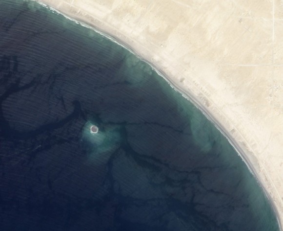
The image above, taken by NASA’s Earth Observing-1 satellite, shows the newly-formed mud island a kilometer (0.6 miles) off the Gwadar coast.
According to an article by the Pakistani news site , the 250-by-100-foot-long pile of mud and rocks is leaking flammable gases.
Pakistan’s many earthquakes are the result of collisions between the
Indian, Arabian, and Eurasian tectonic Source
plates. These sorts of mud
volcanoes are not particularly unusual after large quakes there… it just
so happened that this one occurred near a populated coast and in
relatively shallow water.
The mud volcano, which is being called “Zalzala Jazeera” (earthquake
island) is not expected to last long.
 On the afternoon of Tuesday September 24, 2013, a 7.7-magnitude earthquake struck in southern Pakistan,
causing widespread destruction across several districts during more
than 2 minutes of powerful tremors and shaking. Sadly at least 400
people were killed and over 100,000 have been
left homeless. But effect of the quake
that was soon reported worldwide was the sudden appearance of a new
island off the coast, a mound of mud and bubbling methane seeps rising
nearly 20 meters (70 feet) from the ocean surface.
On the afternoon of Tuesday September 24, 2013, a 7.7-magnitude earthquake struck in southern Pakistan,
causing widespread destruction across several districts during more
than 2 minutes of powerful tremors and shaking. Sadly at least 400
people were killed and over 100,000 have been
left homeless. But effect of the quake
that was soon reported worldwide was the sudden appearance of a new
island off the coast, a mound of mud and bubbling methane seeps rising
nearly 20 meters (70 feet) from the ocean surface.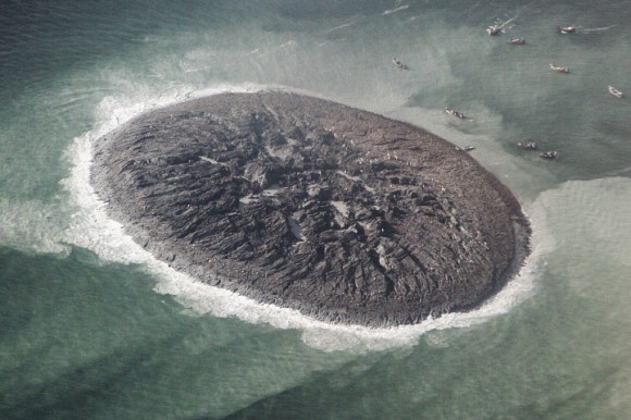


Hmmm...
ReplyDelete